Places to Visit
The highest peak of Bukhansan at 836.5m. A challenging but rewarding summit hike offering panoramic views across Seoul and the Han River.
From Your Hotel Area
→ Baegundae Peak백운대
→ Bukhansan National Park북한산국립공원
→ Bukhansanseong Fortress북한산성
→ Dobongsan Peak도봉산
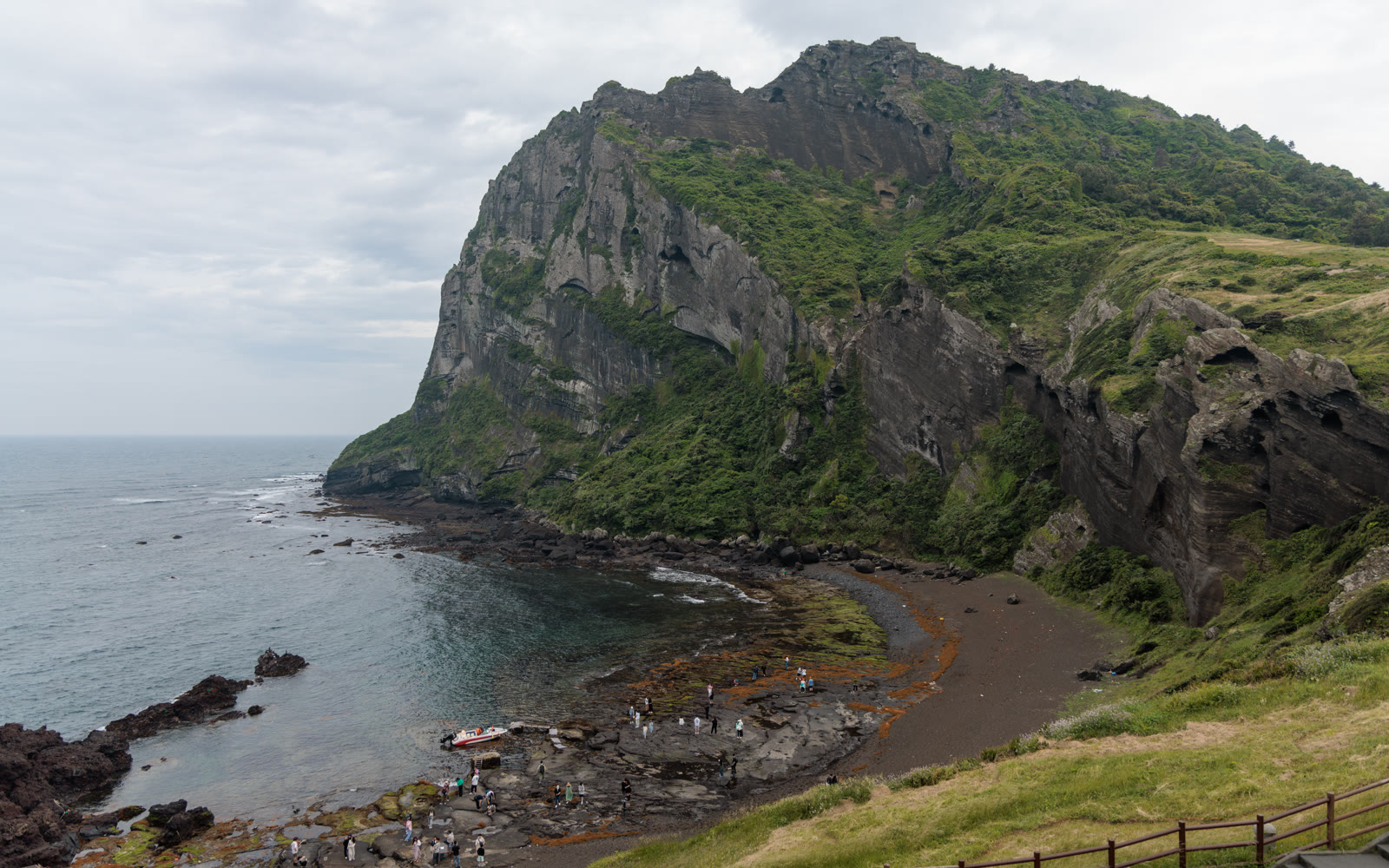
Most cities make you leave to find nature. Seoul is different. Bukhansan National Park sits at the northern edge of the city, reachable by subway in under an hour from anywhere in central Seoul — and once you arrive, the granite peaks, ancient fortress walls, and mountain trails feel like a different world entirely. Spanning the northern districts of Eunpyeong-gu, Seongbuk-gu, and Dobong-gu — with the Dobongsan section in Dobong-gu — the park covers 79.9 km² across northern Seoul and southern Gyeonggi Province and, according to the Korea National Park Service, receives more visitors per square kilometre than any other national park in the world. The main summit, Baegundae, rises to 836.5m. On a clear day from the top, you can see the Han River and the downtown skyline laid out below.
This guide covers three trail options — from an advanced full-day summit push to a more relaxed fortress walk — plus a separate section for Dobongsan, the quieter northern alternative. Directions are given from the three main entry stations, and there is practical advice on what to bring, when to go, and where to eat after the hike.
Trail Options
Trail A: Baegundae Peak Summit (Advanced)
The summit route is Bukhansan's signature hike. From the trailhead, the path climbs steadily through forested slopes before opening onto bare granite faces near the top. The final section to the 836.5m peak involves some light scrambling on fixed ropes — it is not technical climbing, but it requires reasonable fitness and a head for moderate exposure. The views from the summit are the best in the park: Seoul's full skyline spreads south, the Han River glints on clear days, and the rocky ridgeline of Dobongsan is visible to the northeast.
- Difficulty: Advanced
- Distance: 8–10 km round trip
- Time: 4–5 hours
- Start: Bukhansan Ui Station (Ui-Sinseol Line, Exit 1) or Gupabal Station (Line 3, Exit 2)
- Key points: Baegundae Shelter, Insubong granite face, Baegundae summit (836.5m)
Photo Spot: The summit ridge looking south — on clear days you can frame the granite foreground against the Seoul skyline. Arrive before 10:00 for the best light and thinner crowds.
Trail B: Bibong & Bukhansanseong Fortress (Intermediate)
This route combines one of the park's more accessible peaks with a walk along the remains of Bukhansanseong, a Joseon-era fortress wall built in 1711. The fortress stretches across the mountain ridgeline for several kilometres, and sections of the original stone wall are still intact. Bibong (비봉, 560m) is a manageable summit with strong views and a historic stone tablet at the top — the Jinheungwang stele, a boundary marker from the Silla Kingdom (568 AD). The trailhead at Gupabal gives quicker access to the fortress area than the Ui entrance.
- Difficulty: Intermediate
- Distance: 6–7 km round trip
- Time: 3–4 hours
- Start: Gupabal Station (Line 3, Exit 2), bus or taxi to Bukhansanseong entrance
- Key points: Bukhansanseong Gate, Bibong summit (560m), Jinheungwang stele, fortress wall sections
Photo Spot: The intact fortress wall stretching along the ridgeline — shoot along the wall with the mountain valley below. The old stone against the tree canopy is especially striking in autumn.
Trail C: Dobongsan (Intermediate / Advanced)
Dobongsan is technically a separate peak from Bukhansan but falls within the same national park boundary. The trail from Dobongsan station is the most straightforward entry in the entire park — a clearly marked path that rises through a long valley before reaching the main ridgeline at 739.5m. The character of the hike is different from Baegundae: the valley approach is more forested and sheltered, the upper ridgeline is dramatic granite, and the crowds tend to be lighter on weekdays. Dobongsan is a favourite among locals living in the northeastern districts of Seoul.
- Difficulty: Intermediate / Advanced
- Distance: 6–8 km round trip
- Time: 3–5 hours
- Start: Dobongsan Station (Line 1 / Line 7, Exit 1)
- Key points: Dobonggyegok Valley, Cheonchuksa Temple, Dobongsan summit ridgeline (739.5m)
Photo Spot: The ridgeline looking back toward the valley — the layered granite spires frame the forested valley below. Autumn colours on the valley floor make this one of the best foliage shots in Seoul.
Best Time to Visit
Bukhansan is open year-round and each season has its own character. The two peak seasons are spring and autumn.
- Spring (late March – April): Cherry blossoms and mountain wildflowers bloom along the lower trails. The best-known blossom walk is the path from Bukhansan Ui station toward the Doson-sa Temple area. Temperatures are comfortable for hiking and the air is clearer than summer.
- Autumn (October – November): Peak foliage season. The valley forests turn red and gold, and the views from the ridgeline are at their sharpest. This is also the most crowded period — expect full trailhead parking and queues at the Baegundae summit ropes on weekends.
- Winter (December – February): Snow-covered granite peaks are genuinely spectacular. The park stays open but trail conditions require caution. Crampons (아이젠) are essential for the upper sections after snowfall — you can rent them at trailhead gear shops.
- Summer (July – August): The rainy season (장마, jangma) runs from late June through July. Trails can be slippery and some sections are temporarily closed after heavy rain. Heat and humidity make the lower sections uncomfortable. Most experienced hikers avoid July.
Getting There
There are three main trailhead entrances, each served by Seoul Metro. No car is needed.
- Bukhansan Ui entrance (for Trail A and general park access): Take the Ui-Sinseol Line to Bukhansan Ui station, Exit 1. The Ui-Sinseol Line connects at Sinseol-dong (Line 1 / 2) and several other transfer points. From Myeongdong: Line 4 → Dongdaemun History & Culture Park → transfer Line 2 → Sinseol-dong → transfer Ui-Sinseol Line → Bukhansan Ui (~40 min). From Hongdae: Line 2 → Sinseol-dong → Ui-Sinseol Line → Bukhansan Ui (~45 min). From Gangnam: Line 2 → Sinseol-dong → Ui-Sinseol Line → Bukhansan Ui (~50 min).
- Gupabal entrance (for Trail A from the west and Trail B): Take Line 3 to Gupabal station, Exit 2. City bus 704 or a short taxi ride (₩3,000–4,000) reaches the Bukhansanseong park entrance. From Myeongdong: Line 4 → Chungmuro → transfer Line 3 → Gupabal (~40 min). From Gangnam: Line 3 direct → Gupabal (~30 min). From Hongdae: Line 2 → Chungjeongno → transfer Line 3 → Gupabal (~35–40 min).
- Dobongsan entrance (for Trail C): Take Line 1 or Line 7 to Dobongsan station, Exit 1. The trailhead is a 5-minute walk from the exit. From Myeongdong: Line 4 → Seoul Station → transfer Line 1 → Dobongsan (~45–50 min). From Gangnam: Line 3 → Express Bus Terminal → transfer Line 7 → Dobongsan (~50 min). From Hongdae: Line 2 → City Hall → transfer Line 1 → Dobongsan (~50 min).
What to Bring
- Hiking shoes: Trail or hiking shoes with grip are required for the upper rocky sections. Sneakers are manageable on Trail B but risky on Trail A near the summit. Sandals are not suitable for any trail.
- Water — minimum 2L: There are no reliable water sources on the upper trails. Carry more than you think you need, especially in warm weather. Small springs exist at some shelter points but are not guaranteed.
- Snacks and energy food: Most trailheads have convenience stores and small restaurants near the entrance. Stock up before you start — the upper sections have nothing.
- Layering: Summit temperatures are significantly colder than the city, especially in spring and autumn. Pack a windproof layer regardless of the forecast at low elevation.
- T-money card: For all subway and bus connections. See the full guide: How to Get Around Korea.
- Maps app: Naver Maps or KakaoMap work better than Google Maps for Korean trail navigation. Download the Korea National Park Service app (국립공원 앱) for official trail maps and real-time conditions.
After the Hike: Where to Eat
Each of the three main trailheads has a cluster of restaurants serving the food that Korean hikers traditionally eat after a mountain day.
- Bukhansan Ui / Ui-dong area: Several makgeolli (막걸리) houses line the street near the station. The combination of rice wine and pajeon (파전, green onion pancake) is the standard post-hike ritual in Korea. Look for the handwritten signs — these are almost all local family-run spots with no English menus, but pointing works fine. Budget ₩8,000–12,000 per person.
- Gupabal area: The street near the park entrance has doenjang jjigae (된장찌개, fermented soybean stew) restaurants and grilled meat spots. Sanchae bibimbap (산채비빔밥) — mountain vegetable bibimbap — is the local specialty and a natural fit after a day outdoors. Budget ₩10,000–15,000 per person.
- Dobongsan area: Dobongsan-ro is lined with samgyeopsal (삼겹살, grilled pork belly) restaurants aimed squarely at post-hike groups. The long row of identical-looking grilled meat restaurants near Exit 1 has been a Seoul hiking institution for decades. You do not need a reservation — find one with space, sit down, and order. Budget ₩15,000–20,000 per person including drinks.
Tips
- Free entry: Bukhansan National Park charges no admission fee. The trailheads, shelters, and temple grounds are all free to enter.
- Korea National Park Service app: Download the official app before your visit. It has offline trail maps, trail condition updates, and emergency contact information. The app is available in Korean only, but the maps are readable without language skills.
- Start early on weekends: The Baegundae summit trail gets genuinely crowded on weekend mornings from 09:00 onward. Aim to reach the trailhead by 07:00–08:00 for a peaceful ascent and the best light at the top.
- Peak foliage congestion (October – November): Autumn weekends draw some of the largest single-day visitor numbers in the park's calendar. If you visit during peak foliage, weekdays are significantly quieter. The Gupabal–Bukhansanseong route is less congested than the Ui–Baegundae route at this time of year.
- Winter crampons are essential: After snowfall, the granite sections above the treeline become dangerously slippery without crampons. Gear shops at all three trailheads rent crampons for ₩2,000–3,000 per pair. Do not attempt the summit section in icy conditions without them.
- T-money for all transit: All three entrance stations are within Seoul Metro's standard fare zone. Each ride costs ₩1,400–1,600. See the full guide: How to Get Around Korea.